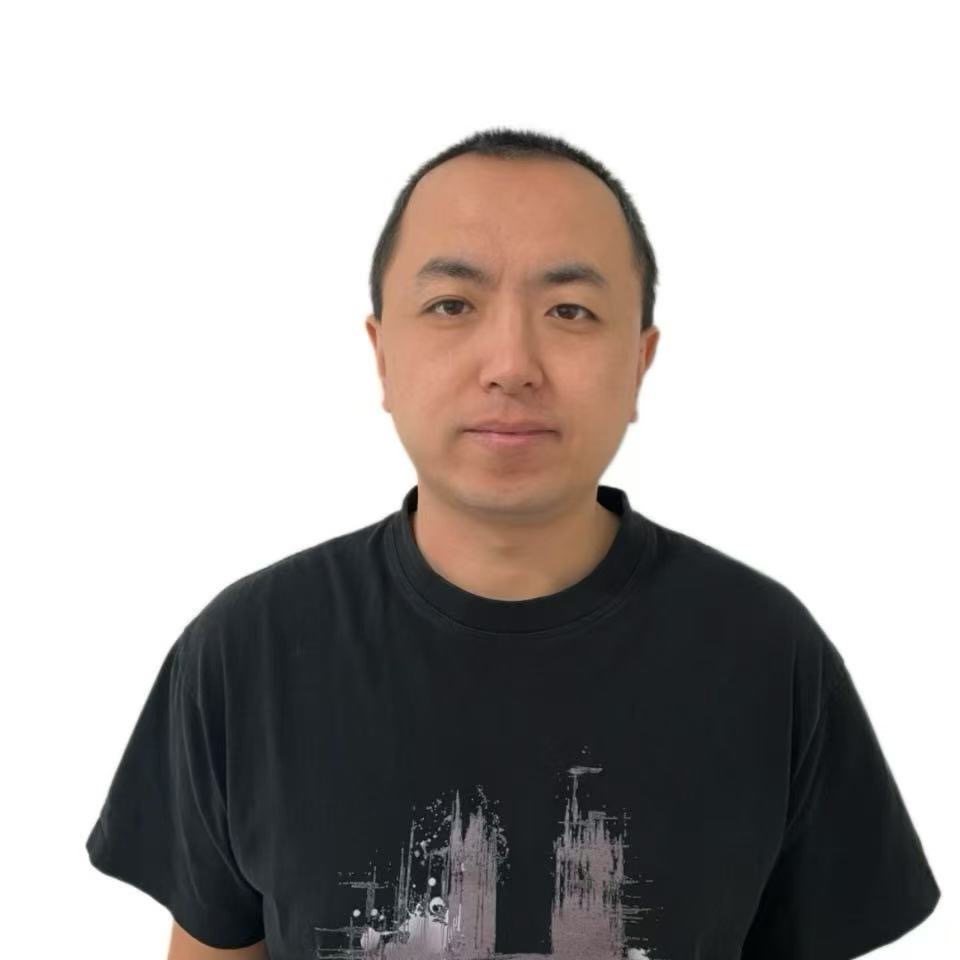
I am a Ph.D. student in Robotics at Georgia Tech, bringing 6+ years of industry experience in autonomous driving — leading the Mapping and Localization team at HoloMatic through production Autonomous Valet Parking and Highway Pilot deployments, with hands-on depth in state estimation, perception, and multi-sensor fusion for real robots (see Work Experience). My research extends that engineering foundation into task-driven, computationally-efficient SLAM for long-term robot autonomy, and has grown my expertise in the directions increasingly central to robotics perception today: 3D Gaussian Splatting and neural scene representations, and foundation models for SLAM.
Open to full-time Perception/Robotics roles and Spring 2027 research internships — feel free to reach out.
🛠 Technical Skills
- Localization & SLAM: Visual & LiDAR SLAM, VIO, Multi-Sensor Fusion, Factor Graphs
- Perception & CV: 3D Reconstruction, Feature Matching, Sensor Calibration
- Machine Learning: PyTorch, Learned Feature Matching (SuperPoint/LightGlue)
- Software & Tools: C++, Python, ROS/ROS2, GTSAM, Ceres, OpenCV
- Domains: Autonomous Driving, Mobile & Legged Robotics
💻 Work Experience
- 2026.05 - 2026.08, Software Engineering Intern, Mapping and Localization, General Motors, Mountain View, CA
- LiDAR mapping/localization and place recognition for autonomous mobile robots on embedded hardware.
- 2017.07 - 2021.12, Senior Research Engineer — Team & Project Lead, Mapping and Localization, HoloMatic Inc.
- Led delivery of production AVP and Highway Pilot systems (visual/LiDAR mapping, VIO, multi-sensor fusion, Semantic SLAM), achieving ~10cm APE/RPE competitive with top-5 KITTI results.
- Enforced automotive-grade, safety-critical C++ standards (MISRA/AUTOSAR-style) across the production codebase.
- 2016.06 - 2017.06, Software Engineer, Autonomous Driving, LeEco Inc.
- Camera calibration and stereo visual odometry for a production perception stack.
- 2015.08 - 2016.05, Senior Research Engineer, Robotics, Institute of Deep Learning (IDL), Baidu Inc.
- Unified camera/LiDAR/IMU calibration framework and global path planning for aerial/ground autonomy.
- 2014.06 - 2015.07, Robotics Specialist, PRECISE Center, University of Pennsylvania
- Vision-based localization and uncertainty-aware planning, including an EKF-VIO system on AR.Drone/MAGIC platforms.
📖 Education
- 2022.01 - now, PhD in Robotics, IRIM, Georgia Institute of Technology.
- 2012.09 - 2014.05, MS in Robotics, GRASP Lab, University of Pennsylvania.
- 2008.09 - 2012.07, BS in Mechanical Engineering, Northeastern University (CHINA).
📝 Publications
[Title] Good Weights: Proactive, Adaptive Dead Reckoning Fusion for Continuous and Robust Visual SLAM
[Author] Yanwei Du, Jing-Chen Peng, Patricio A. Vela.
Adaptively fuses dead reckoning with visual SLAM for continuous, robust pose tracking when visual tracking is unreliable.
Details
The Good Weights algorithm described here provides a framework to adaptively integrate dead reckoning (DR) with passive visual SLAM for continuous and accurate frame-level pose estimation. Importantly, it describes how all modules in a comprehensive SLAM system must be modified to incorporate DR into its design. Adaptive weighting increases DR influence when visual tracking is unreliable and reduces when visual feature information is strong, maintaining pose track without overreliance on DR.
[Title] Task-Driven SLAM Benchmarking for Robot Navigation
[Author] Yanwei Du, Shiyu Feng, Carlton G. Cort, Patricio A. Vela.
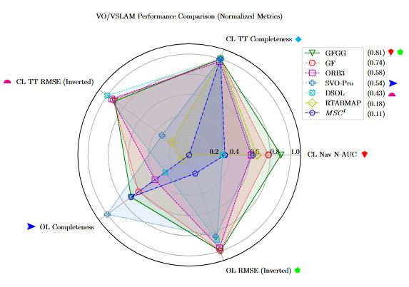
A benchmarking framework that evaluates SLAM methods by task-relevant mapping precision rather than raw trajectory accuracy.
Details
This work proposes a benchmarking framework for evaluating SLAM methods. The framework accounts for SLAM’s mapping capabilities, employs precision as a key metric. The benchmarking approach offers a more relevant and accurate assessment of SLAM performance in task-driven applications.
[Title] Good Graph: Budget-Aware Bundle Adjustment in Visual SLAM
[Author] Yanwei Du, Yipu Zhao, Justin S. Smith, Patricio A. Vela.
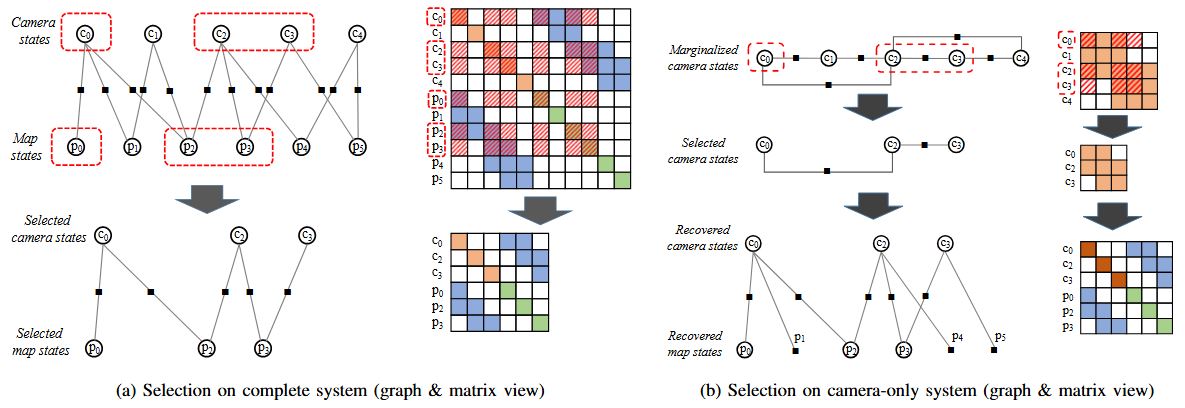
Caps Visual SLAM back-end optimization cost while preserving conditioning, keeping the tracking thread’s map accurate and real-time under a compute budget.
Details
Good Graph is designed to address the critical challenge of computational cost in Visual SLAM back-end optimization. By intelligently capping the problem size while preserving the conditioning of the optimization, it ensures that the back-end remains efficient without sacrificing accuracy. This approach guarantees that the tracking thread receives an up-to-date and accurate map in real time, especially in budget-critical case, thereby enhancing both the accuracy and robustness of the overall Visual SLAM system.
[Title] A Stochastic Approach for Attack Resilient UAV Motion Planning
[Author] Nicola Bezzo, James Weimer, Yanwei Du, Oleg Sokolsky, Sang H. Son, Insup Lee.
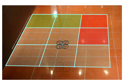
A stochastic motion-planning strategy (Redundant Observable MDPs) for UAVs with unreliable sensor measurements.
Details
This work proposes a stochastic strategy named Redundant Observable MDPs(ROMDPs) for motion planning of unmanned aerial vehicles (UAVs) subject to unreliable sensors measurements.
💬 Research Statement
Simultaneous Localization and Mapping (SLAM) has traditionally been judged by how accurately it reconstructs a scene, with much of the field chasing ever-finer mapping and localization precision. But for a robot executing a task — navigating a warehouse aisle, following a lane, reaching for an object — what matters is repeatability, reliability, and task success, not sub-millimeter accuracy for its own sake. This distinction motivates a shift from accuracy-driven SLAM to task-driven SLAM: systems designed around what the task actually demands of the estimator, rather than a generic accuracy benchmark.
My research pursues this through hierarchical, task-driven estimation, in which multiple estimation modules are tuned to different objectives rather than one estimator being optimized against a single fixed accuracy target. A coarse topological localization layer supplies efficient, high-level location estimates for long-range navigation and situational awareness, while a local environment sensing layer provides the fine-grained feedback that close-quarters tasks — obstacle avoidance, manipulation — actually require. Letting each layer specialize, rather than forcing one estimator to do both jobs at full precision everywhere, yields a system that adapts its robustness/efficiency tradeoff to the task at hand while keeping computation bounded.
This direction is informed directly by my experience deploying safety-critical SLAM in automotive environments, where computational budget and reliability were hard constraints, not afterthoughts. Looking ahead, I am extending this task-driven framework toward emerging representations — 3D Gaussian Splatting and neural scene models — and foundation models for SLAM, asking the same question of these newer tools: not simply how accurate can they be, but how well do they serve the task a robot is actually trying to accomplish, under real computational limits. The goal is robust, scalable systems capable of long-term autonomy in practical, resource-constrained deployments.
🤖 Robotic Platforms
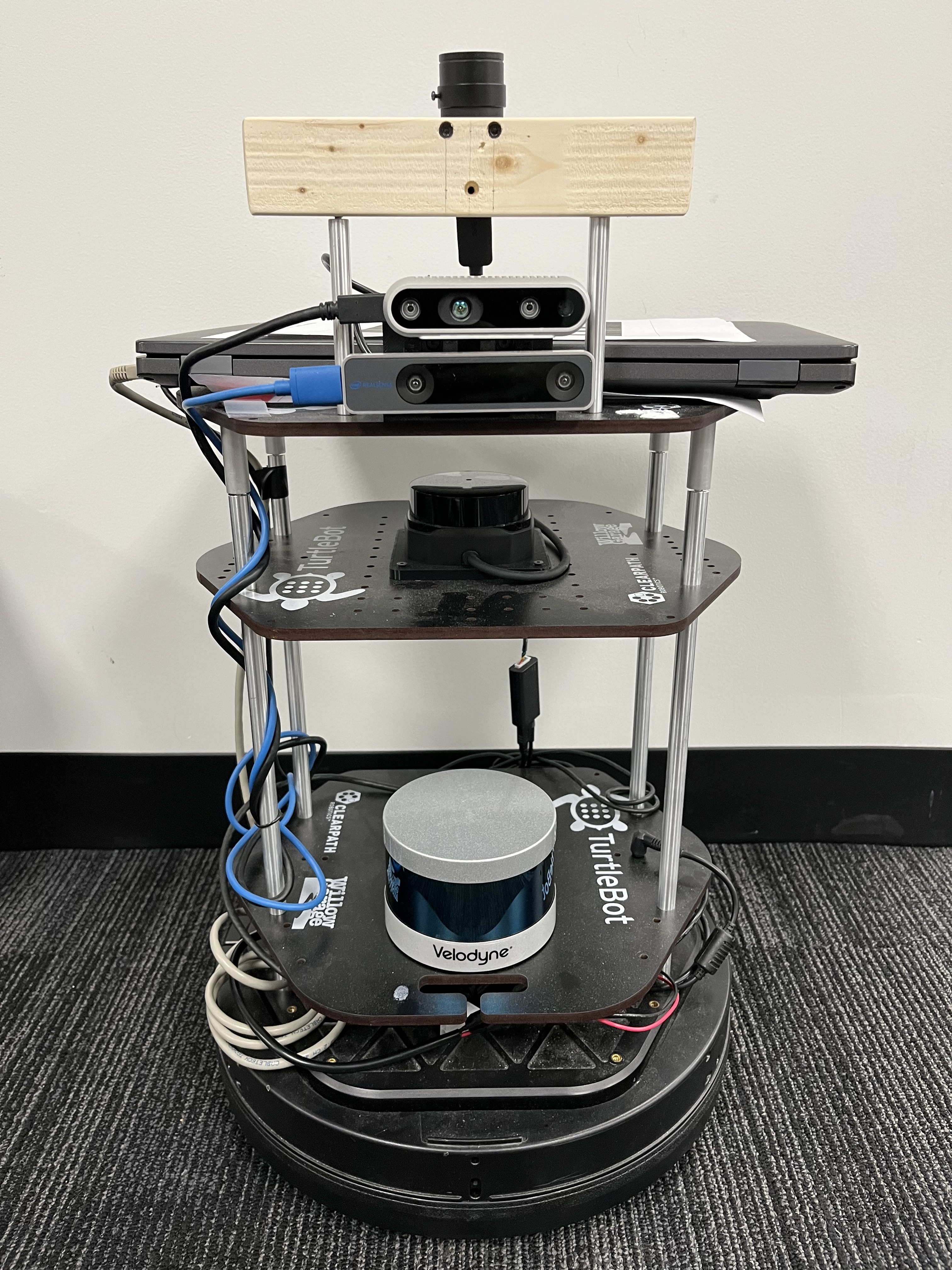
[Title] Custom TurtleBot-Based SLAM Platform
[Description] I design and build custom ground-robot platforms based on the TurtleBot, outfitted with a Velodyne LiDAR, stereo/RGB-D cameras, and a monocular camera on a custom sensor mast, which I integrate and calibrate for closed-loop SLAM evaluation. These platforms serve as the real-robot testbed for my published work, including the Task-Driven SLAM Benchmarking framework (IROS 2025).